During the night, the skies had opened up and dumped rain relentlessly. For the first time ever, my tent failed me. Since the entire field was covered with standing water, it was not surprising that the tent floor finally leaked. In addition, the main seam of the rain-fly was leaking, and rain was dripping down from the ceiling.
When it was finally light, I ate a breakfast of bagels and cream cheese in my tent, dressed, packed my gear, and emerged from my somewhat soggy tent. As the rain was still lashing down intensely, it was impossible to pack the tent without getting it completely soaked. By the time I had finished packing and mounting my panniers, my rain jacket had already failed, and I was soaked to the skin. My new goretex rain pants, on the other hand, were performing excellently, as I was completely dry from the waist down.
I headed around Otter Creek, on my way to Vergennes. Even in the rain, the area was quite beautiful, with its many marshes, bays, etc. Just after I went through Vergennes, I spotted a very small diner that was open on this 4th of July morning. Leaning my bike against a picnic table outside, I opened the door and stepped in. The entire diner consisted of two booths, and a long table in the center of the room. Around this table sat a group of what were obviously local farmers, drinking coffee and discussing the news of the day. As I entered and stood in the center of the room, soaked through and dripping water everywhere, all conversation stopped, and all eyes were on me. "Good morning", I said. "A bit damp, ain't you?", says one of the locals. Don't you just love the dry, Yankee humor? A moment after I had sat down at one of the booths, a woman and her son entered. "Your stuff's getting all wet out there", says the boy. "Getting wet?", I replied. "I think it's as wet as it's going to get."
Soon, I was eating breakfast, and answering a stream of questions about where I had been, where I was going, was I having a good time, etc. I finally left with a chorus of good wishes, and a warm feeling that was derived from more than just the hot coffee.
Eventually, I emerged onto Route 7 right at the Shelburne Museum. It had been my intention to visit this outdoor museum, but the weather canceled those plans. As I crossed to the east side of Route 7, the rain suddenly just stopped. It didn't taper off, it simply ceased raining. It was wonderful to peel off the rain wear. My jersey was soaked, as my rain jacket had failed so miserably.
I headed east to Shelburne Falls, then turned north on Spear Street, which I intended to use as an alternative to busy Route 7 into downtown Burlington. This was another piece of advice I had garnered off the internet, and it worked out exceptionally well. I was able to follow this route right into Winooski, on the north side of Burlington, where I again hooked up with Route 7 and 2. As I followed route 2 out of Burlington, it started to rain again. I decided to forego the rain gear, as it was now too warm to comfortably wear it. Finally Route 2 turned west and headed towards the causeway to South Hero Island. I was on the homestretch, and anxious to see my wife and daughter, who were only a few miles away.
While Route 2 carries plenty of traffic, being the only road onto the Islands, it has a wide, 10 foot shoulder, making cycling a breeze. It also has the dumbest bicycle route I have yet encountered. At the first exit along route 2, there is a 'BICYLE ROUTE' sign pointing off the exit. Thinking that perhaps there is a separate pedestrian/bicycle route across the causeway that is reached via these local roads, I followed the sign. The bicycle route followed these local roads parallel to Route 2 until the road finally dead-ended. Here, the 'BICYCLE ROUTE' sign points up a narrow, paved lane which leads straight up the bank and dumps you right back onto the shoulder of Route 2. The shoulder now has 'BIKE LANE' pained on the pavement, and continues until Sand Bar State Park is reached, just before the causeway leading to the islands. Here, there is a big sign which says 'BIKE LANE ENDS'. The road continues. The 10 foot shoulder continues. The bike lane ends. Huh?
Since my destination is South Hero Island, not Sandbar State Park, I continued along the ample shoulder, wondering what bureaucratic process had managed to design such a ridiculous bike lane. Surely, they never talked to anyone who actually rides a bike. Immediately after reaching South Hero Island, I spotted a sign on the left side of the road for 'Appletree Bay Resort'. This is my destination. This is where my wife and daughter are, anxiously awaiting my arrival. 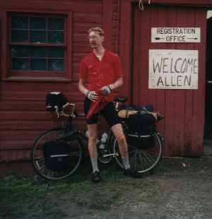 As I pull in, I am greeted by a large sign on the side of the office building which reads "YOU MADE IT ALLEN". Just as I spot the sign, my wife spots me. My daughter runs down the road to give her crazy Dad a big hug. "Did you have fun Daddy? Did you get good exercise?"
You bet I did!
The days statistics:
- 49 miles
- 3:54:25 riding time
- 12.7 mph average speed
Distance from home:
Day 5: Brandon VT to Basin Harbor VT
Epilogue: Observations and Lessons Learned