A late start, and a short day. I left Otter Creek at 8:30, and rode the couple of miles to the Visitor Center at James River. The Park Service has restored one of the locks used on the canal that followed the James River through the mountains here. While they have done an apparently fine job restoring the lock itself, nothing has been done to restore the canal. Just seeing a lock in the middle of what is now a field is rather weird, and I found it hardly worth the time spent to see it.
As I was heading back to my bicycle I met a trio of women who had been out walking along the river. We spent a few minutes discussing the current heat wave. This seemed to be the topic of conversation among everyone I had been meeting this week. If it's hot for the natives, imagine what it was like for a Northerner like myself. While we certainly have hot and muggy weather in New England, it's just not the same thing. At home, a hot day builds throughout the day, and temperatures and humidity will peak in the afternoon. Here in Virginia, temperatures were already into the 90's by 9:00 AM.
From my earliest planning, I knew this would be a decision point for me. South of the James River, the Parkway makes a 12 mile, 3500' climb. I wanted to make this climb, both for the challenge of getting up it, and for the opportunity to turn around and come back down it. Since I had taken a day off at Big Meadows, I no longer had the option of continuing south to Peaks of Otter. While camped at Otter Creek last night, I had toyed with the idea of leaving my panniers at the James River Visitor Center, then climbing the 12 miles up and turning back for the coast down. Taking into consideration the heat today, as well as the fact that my left knee was quite painful already, I knew that attempting to do this climb would be foolhardy. Therefore, I crossed the James River, then exited the Blue Ridge Parkway onto Route 501 west, heading towards the Shenandoah Valley.
Route 501 is a narrow, twisting, two-lane mountain road. It sounds like the perfect cycling route, except that the speed limit is 55 mph, and it is a heavily used truck route through the mountains. My knee was hurting so badly that I had to climb even the gentlest of hills in my granny gear. Riding 501 was not particularly fun or scenic, and sharing the shoulder-less road with so many trucks made for a rather uncomfortable time. On the other hand, the truck drivers made an obvious effort to share the road with me. Several times trucks had to wait for me to negotiate an uphill curve before they could pull out and pass safely. Never once did one do anything that endangered me.
Finally reaching the valley, I turned southwest on Route 130, heading for Natural Bridge. While cruising along the mostly flat 130, a dog started chasing me from a gas station on the opposite side of the road. He was so intent on his quarry (me) that he didn't notice the car which was behind me. As the dog came into the road, he was hit by the following car, rolled three times, and continued running into the woods to my right. Geez, I hope he was all right. The car full of blue-haired tourists didn't even seem to try very hard to brake before hitting the dog.
I stopped at a diner on my way through Natural Bridge Station, getting my usual second breakfast.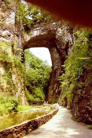 It was only a few more miles after this until I arrived at Natural Bridge itself. This is a pretty heavily developed tourist trap. Acres of parking lots, hotels, motels, wax museum, gift shops, etc. I found a lamp post under the shade of some trees to lock my bike to, then sat down for a few minutes to try to cool off a bit, and maybe even stop sweating. After swapping my cycling jersey for a more 'normal' T-shirt, pulling a pair of shorts on over my cycling shorts, and swapping cycling shoes for sneakers, I looked almost like a normal tourist. Natural Bridge is really quite impressive, well worth the visit. Too bad it's privately owned and so commercialized, but with a little effort you can ignore all that and enjoy it for itself. I spent a couple of hours here, viewing the Bridge itself, as well as mailing a postcard off to my daughter at home. Since there is a Post Office located in the corner of the huge gift shop here, I could get it mailed with a postmark "Natural Bridge". I knew she'd like that!
Spending time off the bike only helped my knee stiffen up even more. My plan for the day was to head north up Route 11 towards Lexington, but instead I decided to head back up 130 to Natural Bridge Station and a campground, Campground at Natural Bridge, located there. By the end of that 5 mile ride I was hurting pretty badly, so knew I had made the right decision in not trying for Lexington. I really don't like stopping too early, especially on a week day when the campground is likely to be quite empty. I have a tendency to get depressed when I have too much time on my hands to be sitting around contemplating my navel. This was true this day, as is evident in a quote from my journal:
Feeling very homesick tonight. Miss June. Miss Anju. Miss the routines of home. But, the challenge of spending time with myself is one of the reasons I travel alone. Nice evening, but still too muggy. The breeze always dies at sunset, and the nights are always uncomfortable. One of these days the rain is going to come, then I'll wish I'd kept my mouth shut!
The days statistics:
- 25.1 miles
- 2:10:56 riding time
- 11.5 average speed
Cumulative Mileage:
Day 6 & 7: Natural Bridge Station to Staunton